Conserving The Jewel Of The Southern Ocean- The South Georgia & South Sandwich Islands Marine Protected Area
April 9, 2025
Since joining GSGSSI in 2018 as Director of Fisheries and Environment, Dr Mark Belchier has been responsible for managing an area of extremely remote sub-Antarctic Ocean to ensure the conservation of the region’s extraordinary marine biodiversity. The South Georgia and South Sandwich Islands MPA has become a model for how conservation can be achieved alongside highly precautionary tourism and sustainable fisheries.
The seas surrounding the remote archipelago of South Georgia, and the South Sandwich Islands are internationally recognized as a biodiversity hotspot. Twice the size of France, the maritime zone is home to globally significant populations of seals, whales, penguins and millions of flying seabirds. These beautiful islands and their extremely rich waters are now highly protected, lying within one of the worlds largest Marine Protected Areas.

The Government’s patrol vessel , Pharos SG, anchored off St Andrews Bay – South Georgia, home to one of the world’s largest king penguin colonies. Photo Steve Brown.
The extraordinary abundance of wildlife is drawn to the archipelago’s beaches to breed, as well as to feed on the huge quantities of Antarctic krill, a highly abundant small crustacean that aggregates in the surrounding sub-Antarctic waters. This scene of seemingly endlessly abundant wildlife that greets today’s visitors is one that would have greeted Captain Cook on his arrival at South Georgia in the Summer of 1775. However, it was Cook’s reports of an abundance of seals with their valuable pelts that ultimately led to the development of South Georgia ‘s sealing industry – the first in a series of industries that, for 200 years plundered the living resources of the region, leading to catastrophic declines of the populations of many of the large charismatic marine mammals for which SGSSI is now famous.
Antarctic fur seals were taken first followed by blue, fin and humpback whales which were hunted to near extinction to supply the whaling stations on South Georgia’s north coast, 100-years after the seals had all but gone. In the mid 1960s, when whales could no longer be found in sufficient numbers, the focus soon turned from hunting to fishing. Unregulated overfishing by Soviet and eastern European fleets led to rapid declines in stocks of fish such as the marbled rock cod and the mackerel icefish until they too were driven towards commercial extinction. The vessels’ use of destructive bottom trawls was widespread, causing untold damage to the fragile animals living on the sea floor. Only when the fishing fleets turned their attention to fishing for Antarctic krill in the late 1970s did the potential threat of unregulated fishing on the whole marine environment became apparent. This led to the first efforts to conserve and manage the region’s marine environment, through the Convention for the Conservation of Marine living resources (CCAMLR) which came into force in 1982.
For a decade, strict fisheries regulations were enacted that were took into consideration not just the potential impact of fishing on the ‘target’ species, but also those on the broader ecosystem and related species. This ‘ecosystem-based approach to fisheries management’ (EBFM) was further strengthened in 1993 with the declaration of a 200nm Maritime Zone around South Georgia and the South Sandwich Islands. This allowed for the greater regulation and enforcement of fishing activities by the Government via a fisheries licensing regime. Many of the measures developed during this period led to considerable reductions in the deaths of seabirds in the region’s fisheries, reductions in bycatch of non-target fish and the implementation of strict controls and catch limits on the harvested species. Additional management tools, including closed areas where fishing was prohibited, increased protections even further. Together these measures formed the basis upon which the Marine Protected Area was developed.
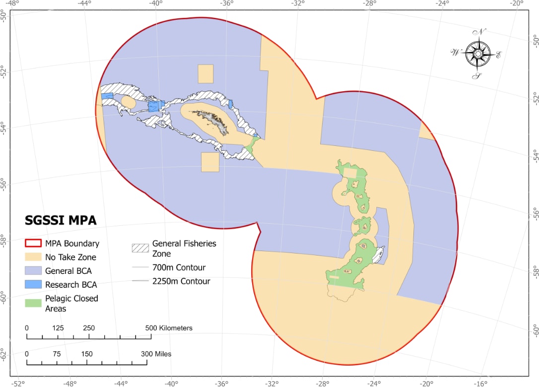
Map of the MPA highlighting the extent of the new protection measures.
The vast South Georgia & South Sandwich Islands Marine Protected Area (SGSSI-MPA) has developed and been enhanced extensively since it was first established by the Government of South Georgia and the South Sandwich Islands in 2012 under new protected area legislation. The 2012 legislation brought together all the existing marine protection measures with the principal objective of ‘conserving marine biodiversity, habitats and critical ecosystem function’. Further expert scientific review in 2013 led to the establishment of a range of zoned areas within the boundary of the MPA including the establishment of 11 no-take-zones (NTZs) where all fishing activity is prohibited, covering an area of 20,400km2, ten benthic closed areas where all bottom fishing is prohibited, a prohibition on the use of all bottom trawl fishing throughout the MPA. A seasonal summer closure of the highly regulated and precautionary krill fishery also reduces overlap with krill feeding predators. At this time the new MPA covered an area exceeding 1 million km2, making it one of the largest in existence. A management plan was developed to enhance the understanding of the MPA measures and their objectives and provide details of how the MPA is managed including permitting, compliance and surveillance. A review system was established, ensuring regular analysis by experts to assess whether the MPA measures were achieving their objectives and remained relevant, whilst also considering whether the research that was needed to assess the MPAs effectiveness in achieving its objectives was being carried out.
Since 2013 two further MPA reviews have been completed with scientific experts working alongside stakeholders representing environmental NGOs, tourism and fishing industry under the guidance of an independent chair to provide advice to GSGSSI. Following the completion of each review in 2019 and again in 2024 there have been significant enhancements made to the MPA and its measures. The 2019 review led to a significant extension of the MPA area to cover all of the SGSSI Maritime Zone totaling 1.24 million km2 whilst the area covered by NTZs, where all fishing activity is prohibited increased to 23% of the MPA total area ( 283,000km2) and was extended to encompass the unique environment of the South Sandwich Islands trench, which extends to depths exceeding 8000m (as deep as Mount Everest is high), and the highly diverse seabed habitats and seamounts lying south of 60oS. Additionally the seasonal closure of the krill fishery was extended by two months based on new data on whale and penguin foraging whilst a complete ban on the use of highly polluting heavy fuel oil (HFO) by vessels operating within the MPA was introduced.
On behalf of GSGSSI, lead scientists from the British Antarctic Survey (BAS) have since developed a research and monitoring plan (RMP) [.pdf] for the MPA to guide and inform on the range of science activities that will best provide the information necessary to manage the MPA and assess its overall effectiveness. As part of this project, a web-based dedicated data portal was developed to allow the public to visualize the MPA measures and explore the supporting scientific data. As a result of the 2019 review, considerable resources were invested by the GSGSSI and the UK (through the UK’s Blue Belt programme) to investigate the region and obtain scientific information on the marine ecosystem surrounding the South Sandwich Islands- which were only very rarely investigated due to their exceedingly remote location and unforgiving and unsheltered environment. Major research surveys were carried out in the region in 2019/20 on board the RRS Discovery.
The conclusion of the most recent MPA review in 2024 led to further enhancements being brought into force place including an additional 187, 000 km2 of No take Zone covering regions noted for their importance for use by marine mammals including humpback whales and fur seals. Much of the area of these important marine mammal areas (IMMAs) and key biodiversity areas (KBAs) are closed to all fishing and form a continuous linked region throughout the MPA. Additional closures have been introduced to enhance the protection for the seabed.
The MPA now covers an incredible 1.24 million km2 of ocean, encompassing an extraordinary array of habitats and distinct ecosystems including hydrothermal vents and sea ice zones. Around 37% of the MPA is completely closed to all fishing activity (and this region includes all coastal regions and the most biodiverse regions and those that contain the highest abundances of marine life.) Highly regulated sustainable longline fisheries for toothfish are restricted to a narrow depth band limiting their operation to < 5% of the MPA resulting in closure of 95% of the area to all fishing on the seabed. The revenue generated largely from the sale of fishing licences for the highly regulated toothfish and krill fisheries at South Georgia is used to fund the year-round presence of the Government’s patrol vessel Pharos SG. The vessel, coupled with airborne and satellite surveillance funded through the Blue Belt programme, has contributed to a massive reduction in the threat of illegal, unreported and unregulated (IUU) fishing and the terrible impact such activities can have both on target and bycatch species and the wider ecosystem. Fishing and tourism revenue also funds the extensive science activity centered around the research station at King Edward Point (KEP) where year-round science is carried out by BAS in support of the management of the Territory’s marine and terrestrial environment. This surveillance and science capability is vital for the long-term management of one of the most remarkable regions of the world’s oceans.
There are highly encouraging signs within the MPA ranging from the significant increase in whale numbers throughout the year to the recovery of previously overfished fish stocks such as the marbled rock-cod. Climate change will undoubtedly present future challenges to the region’s wildlife, but the MPA measures underpinned by a strong research and monitoring presence coupled with strict enforcement, surveillance, management and review should ensure the effectiveness of the MPA is maintained enabling future generations to experience this amazing global rarity, an ecosystem in recovery.

Gentoo and king penguins share the beach at Maiviken, South Georgia with Antarctic fur seals Photo: M. Belchier

A majestic wandering albatross and chick at Prion Island. South Georgia. Deaths of seabirds in South Georgia’s highly regulated longline fishery has been reduced to close to zero since strict mitigation measures were introduced and enforced. Photo: Daniel Johnson.

A marbled rock cod (Notothenia rossii) swims close to the seabed in Cumberland Bay, South Georgia which forms part of the extensive No Take Zone covering around 37% of the MPA. Photo: GSGSSI/Cefas/Blue Belt

Corals, sea urchins and brittle stars abound at 600m depth with a ‘Benthic Closed Area’ at Shag Rocks, where fishing on the seabed is prohibited. Photo: GSGSSI/Cefas/Blue Belt
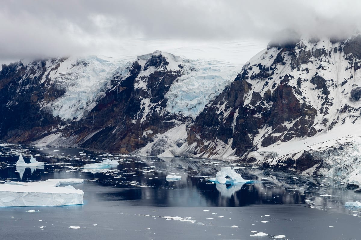
Photo: BFSAI – Cpl Cannt